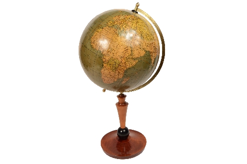
1752587793Code 8192 Terrestrial GlobeTerrestrial globe published by Räths Politischer Erdglobus, designed and outlined by Professor Arthur Krause in the 1930s. In addition to the territorial map, it also depicts ocean currents and the main trade routes of the period.
Papier-mâché sphere complete with engraved brass meridian circle, excellently crafted turned wooden base.
Good condition, some signs of use.
Dimensions: 33 x 65 cm – 13 x 25.6 inches.
Professor Dr. Arthur Krause took over the Räth company, a globe manufacturer founded in 1917 by Paul Räth (1881–1929), after the founder's death. The company is still in operation today, having survived two world wars and the dissolution of the GDR. Some Räth globes are exhibited in major museums, such as the first electrically illuminated globe, from 1921, on display at the Globe Museum of the Vienna National Library.
The first recorded terrestrial globe is the one attributed by Strabo, historian and geographer, to the Greek Crates of Mallo (c. 150 BC). The first globes, constructed in the early 16th century under the impetus of great geographical explorations, immediately began to be used for educational purposes in princely courts, monasteries, and colleges; the globe later began to conquer universities and high schools. In the 18th century, the official geographer of Louis XV, King of France, Didier Robert de Vaugondy, thanks to the practice acquired in the construction of globes, expanded the article “Globe” of the Encyclopédie by illustrating in detail the distinction between a celestial globe (which represents the concave surface of the sky with its constellations) and a terrestrial globe (which instead represents the surface of the Earth with the seas, islands, rivers, cities, etc.) and the techniques for making them: two papier-mâché hemispheres pressed and modelled on or inside a hemispherical mould, dried and strengthened on the inside with a wooden board, then glued and covered with a thin layer of plaster on which the spindles were glued.
of the globe of areas between two meridians, usually twelve, on paper previously printed from copperplate engravings and colored, each covering 30 degrees of longitude. It was with the 19th century, with its widespread trade, circulation, and the introduction of compulsory education, that the desire to explore distant lands increased, making the old method of globe construction inadequate. Maps printed from engraved plates were no longer sufficient, and the only real resource became lithography, which made it possible to print and promptly update maps that, with the growth of geographical discoveries in various countries, became increasingly obsolete.