In addition to the Gallery in Milan, opened in 1999, Antik Arte & Scienza has also had a channel for online sales: on this site it is possible to buy, in fact, nautical antiques, astronomical instruments, globes and antique world maps, antique compasses, measuring instruments, vintage medical instruments and related to natural history. We know how it is important to offer secure and easy on-line purchases and therefore we have decided to offer free shipping and free insurance. All objects have an accurate and safe packaging, and when necessary also a padded wooden box made to measure. Shipping is insured by Lloyd's London, and you have 28 days to change your mind and return the bought items (see our general selling conditions for more information about return methods).
The first globe we know is attributed by Strabo, the historian and geographer, to Cratete from Mallo (about 150 B.C.). In the early XVI century, they were made the first globes because of geographical explorations and they were used for didactic purposes in courts and colleges, then in universities and high schools.
1602078954Code 610 Antique geographic mapMap depicting the entire earth’s surface divided into two parts corresponding to the two hemispheres and showing the Arctic to Antarctic polar circle, the tropics of Cancer and Capricorn, the equator and the equinoctial line.
Detailed explanation in French.
Printed on paper by engraving on copper plate, coeval coloring.
Table n. 2, French manufacture from the mid-19th century, non-contemporary frame made of cherry wood.
Size with frame 70.5x47 cm - 27.7x18.5 inches, thickness of the frame 2 cm - 0.78 inches.
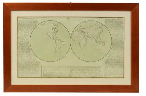
608Code 608 Antique geographic mapGeographical map depicting the entire earth’s surface divided into two parts that correspond to the two hemispheres where the emerged lands are depicted which have been classified with letters based on the morphology of the land. The continents are marked with the letter A, the islands with the letter B, the promontories with the letter F, the cliffs overlooking the sea with the letter G, the dunes with the letter H, etc. Detailed explanation in French. Printed on paper by engraving on copper plate, coeval coloring. Table n. 11, French manufacture from the mid-19th century, non-contemporary frame made of cherry wood.
Size with frame 66x47 cm - 25.9x18.5 inches, thickness of the frame 2 cm - 0.78 inches.
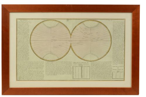
609Code 609 Antique geographic mapGeographical map depicting the entire earth’s surface divided into two parts that correspond to the two hemispheres divided into small climatic zones that depict the climatic trend from the Arctic circle to the equator. Detailed explanation in French. Printed on paper by engraving on copper plate, coeval coloring. Table n. 15, French manufacture from the mid-19th century, non-contemporary frame made of cherry wood.
Size with frame 70.5x47 cm - 27.7x18.5 inches, thickness of the frame 2 cm - 0.78 inches.
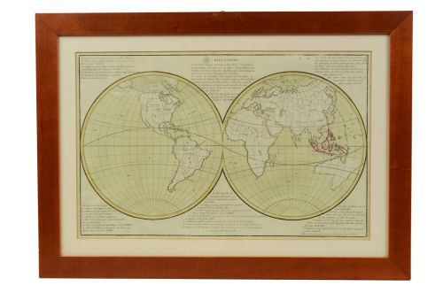
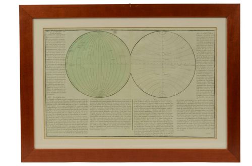
611Code 611 Antique geographic mapGeographical map depicting the entire earth’s surface divided into two parts that correspond to the two hemispheres or globes, the map deals with the Earth in general. Detailed explanation in French. Print on etching paper on copper plate, coeval coloring. Table n. 8, French manufacture from the mid-19th century, non-contemporary frame in cherry wood. Size with frame 69.7x46.5 cm - 27.44x18.3 inches, frame thickness 2 cm - 0.78 inches.
612Code 612 Antique geographic mapGeographical map depicting the entire earth’s surface divided into two parts that correspond to the two hemispheres or globes, the map deals with the latitudes and longitudes, the meridian 0 is indicated, also called the meridian of France fixed by Louis XIII in 1634 because it crossed the whole territory from Perpignan to Dunkerque and then replaced in 1884 by the Greenwich meridian. Detailed explanation in French. Printed on paper by engraving on copper plate, coeval coloring. Table n. 3, French manufacture from the mid-19th century, non-contemporary frame in cherry wood. Size with frame 65.7x47.2 cm - 25.8x18 inches, frame thickness 2 cm - 0.78 inches.
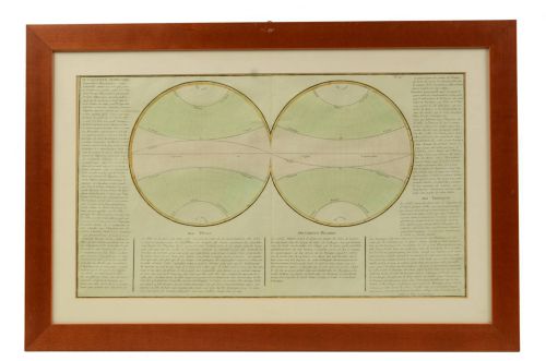
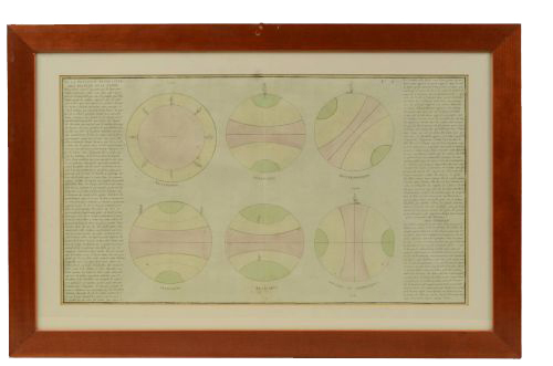
613Code 613 Antique geographic mapMap depicting the entire earth’s surface divided into six parts which depicts the position of peoples on Earth based on the assumption that it is impossible for each people to have the same relationship with Heaven, seasons, and days and hours at the same time of the day. Detailed explanation in French. Printed on paper by engraving on copper plate, coeval coloring.
Table n. 6, French manufacture from the mid-19th century, non-contemporary frame made of cherry wood.
Size with frame 70.5x47 cm - 27.7x18.5 inches, thickness of the frame 2 cm - 0.78 inches.
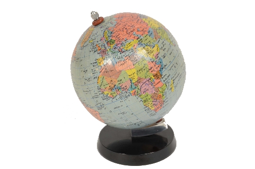
1602856172Code 6657 Vintage globeTerrestrial globe published in the forties by Girard Barrère et Thomas 17, Rue de Buci Paris. Turned wooden base, paper mache sphere covered with paper printed by engraving on copper plate and watercolored. In addition to the territorial map, the ocean currents and the main trade routes of the period are depicted. Excellent condition. Height 48 cm, sphere diameter 23 cm - inches 9x18.8.
1645631427Code 7219a Small Terrestrial GlobeSmall terrestrial globe signed C.M.C. Paris, end of XIX century. Papier maché sphere and turned and ebonized wooden base.
Height cm 13 - inches 5.1, diameter of sphere cm 6,5 - inches 2.6.
Very good condition.
1709811598Code 7885 Terrestrial GlobeTerrestrial globe published for the Dutch market in the early 20th century by the Columbus publishing house, the title block reads: Aardglobe by Dr. R. Neuse. Nederlandsche bewerking van R.E. KALTOFEN Leeraar Rijks H.B.S. Utrecht UITGAVE ERVEN J. BIJLEVELD. Utrecht. Columbus-Verlag G.m.b.H. Berlin Lichterfelde. In addition to the territorial map, the ocean currents and the main trade routes of the period are depicted. Base in turned wood and sphere in paper mache covered with the 12 spindles and the two caps on paper printed by engraving on copper plate and watercoloured. Height 39 cm – 15.4 inches, sphere diameter 18 cm – 7.1 inches. In good condition, some signs of wear, very good readability.
1714818972Code 7889 Terrestrial GlobePolitical desktop terrestrial globe, published in the 1960s by Rand McNally. Embossed paper mache sphere, base and complete circle of the graduated merian in metal. In good condition, very good readability. Height 43 cm – 16.9 inches, sphere diameter 30 cm – 11.8 inches.
1730996849Code 8038 Terrestrial GlobeTerrestrial globe published by the German cartographic institute Dietrich Reimers Berlin 1954. In addition to the very well-defined territorial map, the ocean currents and the main trade routes of the period are shown. Rectangular wooden base complete with meridian circle. Good condition, excellent readability. Height 34 cm – 13.3 inch, sphere diameter 23 cm – 9 inch.
1730999043Code 8040 Small Terrestrial GlobeSmall German terrestrial globe published by Columbus Schulerglobus, cartographer Prof Paul Oestergaard Berlin Stuttgart in the 1950s. Turned wooden base complete with engraved meridian circle. Good condition, excellent readability. Height 19 cm – 7.5 inch, sphere diameter 10 cm – 3.9 inch.
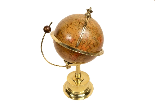
1732200986Code 8029 Globe with ClockChronosphere, a clock surmounted by a globe that rotates over the course of 24 hours so as to read the hours in all time zones.
Local time is indicated by a brass hand.
Eight day charge.
French manufacture for the English market of the late 19th century.
The writing is engraved on the brass base: Bté S.D.G.D is a French patent which was in force from 1844 until 1968, which means a patent without government guarantees.
Mechanism serviced and working, but not perfectly on time, globe with abrasions and signs of use, good readability. Height 30 cm – 11.8 inches - sphere diameter 15 cm – 5.9 inches.
A ring gear on the South Pole of the globe is connected to the shaft of the clockwork mechanism which is located inside the grooved brass column, connected to the base of the drum which contains the clockwork mechanism. The brass ring that represents the equator has the hours engraved in Roman numerals, in red for the day and in black for the night, the time is indicated with a bent brass hand that starts from the north pole, while on the circle of the equator you can read the hours at various latitudes. The Moon is depicted by a small burnished brass globe screwed onto a partially threaded brass bow, to allow the Moon to change its position relative to the Earth. The continents are depicted on the globe and in detail China is indicated as the Chinese Empire as it was called before the Revolution, just as Russia is indicated as the Russian Empire, while the British possessions around the world are highlighted in red. The watch has an eight-day charge, both charging and setting the time must be done on the bottom of the base, using a double key.
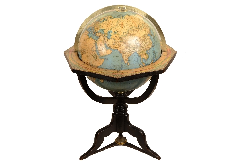
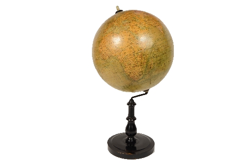
1742646498Code 8113 Terrestrial GlobeTerrestrial globe published in 1868 by Verlag Dietrich Reimer by the cartographer Carl Adami. Ebonized wooden basket tripod base with compass at the base, papier-mâché and plaster sphere covered with copper plate engraving paper. In addition to the very well-defined territorial map, the main trade routes of the period are shown, terrestrial sphere complete with the engraved brass meridian circle. Height cm 74 – 29.1 inch, base diameter cm 46 – 18 inch, sphere diameter cm 30 – 11.8 inch. Good condition and good readability
1742659757Code 8110 Terrestrial GlobePolitical globe copyright The George F. Cram Co inc. Indianapolis Indiana Made in USA from the sixties. Metal base, papier-mâché sphere. In addition to the very well-defined territorial map, the main trade routes of the period are depicted. Good condition. Height cm 29 – inches 11.4, diameter of the sphere cm 21 – inches 8.3.
1744467222Code 8115 Terrestrial GlobeTerrestrial globe published for the Dutch market in the early 20th century by the Columbus publishing house, on the cartouche we read: Aardglobe by Dr. R. Neuse. Nederlandsche bewerking van R.E. KALTOFEN Leeraar Rijks H.B.S. Utrecht UITGAVE ERVEN J. BIJLEVELD. Utrecht. Columbus-Verlag G.m.b.H. Berlin Lichterfelde.
In addition to the territorial map, the ocean currents and the main trade routes of the period are depicted.
Papier-mâché sphere complete with engraved brass graduated meridian, oak basket base with compass at the base.
Good condition conservative restoration signs of use. Sphere diameter cm 30 – inches 11.8, base cm 48x62 – inches 18.9x24.4.
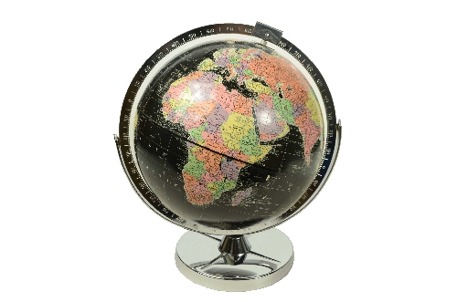
1748535465Code 8148 Black Terrestrial GlobeBlack terrestrial globe from the Encyclopedia Britannica from the 1960s. Chromed metal base complete with the full circle of the meridian,
Papier-mâché sphere with the oceans and black seas, in addition to the territorial map with bright colors, some of the main trade routes of the period are shown, and as indicated in the legend, capitals and cities, railways, steamship lines, canals, mountain peaks are included.
Good condition, some signs of use, excellent readability. Measurements cm 30x41 – inches 11.8x16.1.
1748699215Code 8099 Terrestrial GlobeTerrestrial globe published at the end of the 19th century by the French geographer J. Forest; in addition to the territorial map, the ocean currents and the main trade routes of the period are depicted. Papier-mâché and plaster sphere covered with sections of copperplate engraving paper and watercolour, base in turned and ebonised wood. Height cm 35 – inches 13.8, diameter of the sphere cm 19 – inches 7.5. Good condition, signs of use and signs of restored woodworm on the base.
1749482478Code 8153 Vesuvius Eruptions PrintPrint from the end of the 18th century, depicting the volcanic eruptions of Vesuvius published by Raffaello Morghen (1758-1833). The print reads the following description: Plan of the volcano of Naples called Vesuvius; with the increasingly remarkable eruptions that followed in several Times.
A eruption followed in the year 1723. B eruz. in the year 37. C eruz. in the year 51. D eruz. in the year 52. E eruz. in the year 60. F eruz. in the year 67. G eruz. in the year 70 in the site called atrium of the horse.
Inside a cartouche there is the following dedication: A.S.A Mad.ma Princess Jablonouka born Princ.sa Sapieha, Palatine of Braclau.
Filip. Morgh. Fc.
Frame shaped in walnut with some signs of woodworm. Print dimensions 39x28.4 cm – 15.4x11.3 inches, frame dimensions 77x61.5 cm – 30.3x24.2 inches.
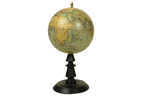
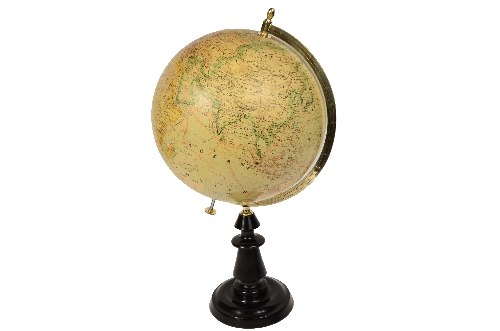
1749571458Code 708 Terrestrial GlobeTable globe made by the geographer and cartographer of the Austro-Hungarian Empire Jan Felkl in the second half of the 19th century.
In addition to the territorial map, the ocean currents are reported.
Turned and ebonized wooden base, papier-mâché and plaster sphere covered with spindles and caps for lithographic printing.
Very good state of readability and conservation.
Dimensions diameter sphere cm 20 – 7.9 inches, height cm 45 – 17.8 inches.
1752659095Code 8195 Small Terrestrial GlobeSmall globe published by Räths Politischer Erdglobus, designed and outlined by Prof. Arthur Krause in the 1950s. Papier-mâché sphere and Bakelite base.
Good condition, excellent readability. Dimensions: 11 x 16.5 cm – 4.4 x 6.2 inches
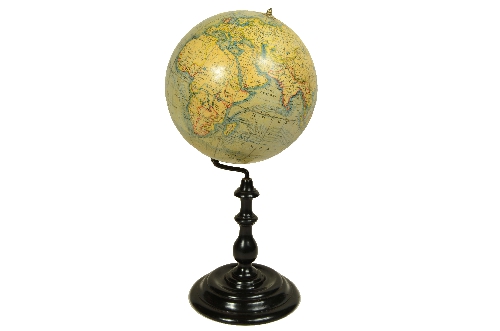
1752933186Code 709 Terrestrial GlobeTerrestrial globe made by the Austro-Hungarian geographer and cartographer Jan Felkl in the second half of the 19th century. In addition to the territorial map, it also shows ocean currents. The base is made of turned and ebonized wood. The sphere is made of papier-mâché and gesso, and features spindles and caps from lithographic printing. In good condition, cleaned and restored. Dimensions: 30 x 60 cm (12 x 23.6 inches).
1752933783Code 8190 Terrestrial GlobeTerrestrial globe published in the second half of the 19th century by French geographer Joseph Forest; in addition to the territorial map, it depicts ocean currents and the main trade routes of the period. Papier-mâché and plaster sphere covered with lithographed and watercolored paper segments, turned and ebonized wooden base, complete with engraved brass meridian semicircle.
Good condition, cleaned and restored. Dimensions: 32 x 60 – 12.6 x 23.6 cm.
1761925081Code 8276 Terrestrial GlobeEarth globe made at the end of the 19th century by Ernst Schotte of Berlin.
In addition to the territorial map, ocean currents are depicted. Base in turned and ebonized wood, papier-mâché sphere. Good condition, signs of use, very good readability. Measurements 29 x 65 cm – 9.4 x 25.5 inches
1764079820Code 8338 Terrestrial GlobePolitical table globe, produced in the 1950s by Weber Costello Co., Chicago Heights, Illinois, and surmounted by an aluminum Lockheed Super G Constellation airplane, a symbol of the expansion of commercial aviation of the period.
The sphere is made of lithographed paper and, in addition to the territorial map, shows the main trade routes of the Super G Constellation and ocean currents. The globe comes complete with an aluminum base and meridian semicircle; the airplane is cast aluminum.
Dimensions: Sphere diameter: 17 cm (6.7 in). Height: 30 cm (11.8 in). Airplane width: 26 cm (10.2 in).
Good condition.
1764080789Code 8341 Small Terrestrial GlobeSmall German globe made by the cartographer Columbus Schulerglobus, Prof. Paul Oestergaard, Berlin–Stuttgart, in the 1950s.
In addition to the territorial map, it depicts ocean currents and the main trade routes of the period.
Aluminum base, complete with engraved meridian circle. Good condition, with slight paper abrasion over Australia.
Height: 21 cm (8.2 inches); sphere diameter: 13 cm (5.1 inches).
1764085271Code 8334 Terrestrial GlobeTerrestrial globe with black seas and oceans, from Cram’s Universal Terrestrial Globe, 12-inch, produced by the George F. Cram Company of Indianapolis, one of the most influential American cartographic companies active between the second half of the 19th century and the mid-20th century. The company, founded by George Franklin Cram, specialized in the production of atlases, maps, and school globes, using innovative printing techniques that made globes accessible to a wider audience.
Chromed metal base with clean geometric shapes and a metallic meridian: a clear example of Art Deco design, typical of the years between 1935 and 1941.
Good condition, signs of use and abrasions, good legibility.
Dimensions: 30 x 42 cm – 11.8 x 16.5 in
1764951564Code 8347 Terrestrial GlobeTerrestrial globe published in the 1930s by Weber Costello, with an attractive plaster base featuring a relief-printed compass rose, complete with a bronze meridian circle.
The papier-mâché sphere is lithographed; in addition to the territorial map, it also shows the ocean currents and major trade routes of the time. As indicated in the legend, capitals and cities, railways, steamship lines, canals, and mountain peaks are included.
It is in good condition, with normal signs of use and some losses along the equator; legibility remains very good.
Dimensions: 24 x 34 cm – 9.5 x 13.4 in.
The globe also features a large figure-eight analemma, positioned in the Pacific, which shows the solar declination and the equation of time throughout the year: a characteristic feature of pre-war educational globes, when astronomy applied to navigation still played a key role in schools.
1764957656Code 8368 Terrestrial GlobeTerrestrial globe with black seas and oceans, published by REPLOGLE Globes inch, Chicago, in the 1950s.
Lithographed papier-mâché sphere, chrome-plated metal base and meridian circle.
Good condition, some signs of use, excellent legibility.
Dimensions: 30 x 41 cm – 12 x 16 in.
1764958168Code 8353 Terrestrial GlobeBlack decorative physical terrestrial globe topped with an aluminum airplane.
Sphere in silver-colored lithographed paper on a black background, aluminum base and meridian circle.
Made in USA 1980s.
Dimensions: Sphere diameter 12 cm - 4.7 in, airplane length 16 cm - 6.3 in, height 28 cm - 11 in.
1764958505Code 8354 Lunar GlobeThe cartouche reads: REPLOGLE LUNAR GLOBE. Diameter 12 inches, scale 180 mi. per inch. Made in the USA in the 1970s.
Lithographed paper sphere and Bakelite base.
Dimensions: 30 x 36 cm – 12 x 14.2 in.
The 12" Replogle Moon Globe is a tabletop lunar globe that depicts the surface of the Moon with craters, maria, and reliefs.
1765022727Code 8362 Terrestrial GlobeLightly embossed globe with dark blue seas and oceans, published by REPLOGLE Globes inch Chicago in the 1960s.
Lithographed papier-mâché sphere, gray painted metal base and meridian circle.
Good condition, some signs of use, excellent readability.
Dimensions: 30 x 41 cm – 12 x 16 in.
1765030673Code 8366 Terrestrial GlobeSlightly embossed globe with black seas and oceans, published by REPLOGLE Globes inch Chicago in the 1960s.
Lithographed papier-mâché sphere, gray painted metal base and meridian circle.
Good condition, some signs of use, excellent readability.
Dimensions: 30 x 41 cm – 12 x 16 in.
1765126223Code 8217 Terrestrial GlobeTerrestrial globe published in the second half of the 19th century by the Peter J. Oestergaard Cartographic Institute in Berlin.
Papier-mâché sphere covered with 12 spindles and two polar caps printed on lithographically printed paper, turned and ebonized wooden base complete with an engraved brass meridian circle.
The globe shows the political boundaries of the time, cities, railways, sea routes, and rich geographical details.
Good condition, signs of oxidation, very good legibility.
Dimensions: 33 x 62 cm – 13 x 24.5 in
1765126867Code 8388 Large Terrestrial GlobeLarge globe published in the 1940s by Paravia based on a design by C. Boehmer.
In addition to the territorial map, ocean currents are depicted.
Papier-mâché and plaster sphere covered with twelve spindles and two lithographed paper caps, base and meridian circle in burnished metal.
Good condition, two conservative restorations on the Atlantic Ocean and soldering on the base, very good legibility.
Dimensions: 58 x 70 cm – 22.8 x 27.5 in.
1765131370Code 8333 Terrestrial GlobePolitical tabletop globe with a stylized Art Deco airplane-shaped base, produced in 1930 by Weber Costello Co., Chicago Heights, Illinois.
This lithographed papier-mâché globe features a territorial map, ocean currents, and major trade routes of the period. As indicated in the legend, it includes capitals and cities, railroads, steamship lines, canals, and mountain peaks. Both the airplane-shaped base and the meridian semicircle are made of zamak.
The globe also features a large figure-eight analemma, positioned in the Pacific, showing solar declination and the equation of time throughout the year: a characteristic feature of pre-war educational globes, when astronomy applied to navigation still played a key role in schools.
Good condition, with some stains and signs of wear. Dimensions: sphere diameter 30 cm – 12 in, height 40 cm – 15.8 in
1769181592Code 8381 Terrestrial GlobePolitical table globe with an airplane-shaped base, published in 1949 by Weber Costello Co., Chicago Heights, Illinois.
This papier-mâché globe features a territorial map and the major trade routes of the period. As indicated in the legend, it includes capitals and cities, railroads, steamship lines, canals, and mountain peaks.
Both the airplane-shaped base and the meridian semicircle are cast metal, subsequently chromed and burnished.
In good condition, the sphere is oxidized, but legibility is excellent. Some small abrasions on the paper at the equator.
Dimensions: 30 x 40 cm – 12 x 16 in.
1769185464Code 8384 Terrestrial GlobeDecorative physical terrestrial globe topped with an aluminum airplane. Color lithographed paper sphere, aluminum base and meridian circle. American manufacture, 1980s. Dimensions: Sphere diameter 20 cm – 7.9 in, airplane length 23 cm – 9 in, height 40 cm – 15.8 in.
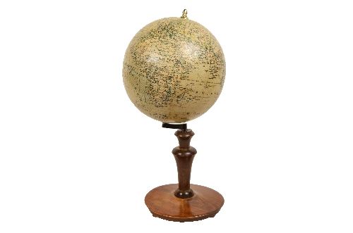
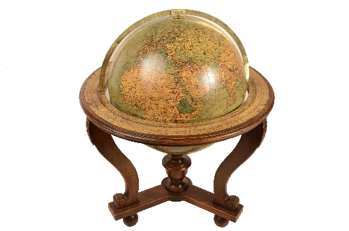
1769270083Code 8236a Terrestrial GlobeTabletop terrestrial globe, crafted according to the knowledge of Giovanni Maria Cassini (Venice 1745 – Rome 1824), a cleric regular of the Somaschi Fathers, an order proposed in Venice in 1525 and founded in Somasca, Lombardy, in 1532.
The globe was updated and reprinted according to the latest discoveries in 1843 by Calcografia Camerale, the papal publishing house, at a time when numerous colonial borders were being redrawn, new explorations in Oceania and Africa were taking place, and new geographical names were beginning to appear. This makes the globe even more interesting as a historical document, as it demonstrates the evolution of cartography in the first half of the 19th century.
Composed of twelve spindles and two polar caps, copper-engraved on paper and applied to a plaster and papier-mâché support, hand-colored, and placed on an octagonal wooden pedestal.
Good condition, showing signs of use.
Measurements 50x50 cm – 19.7x19.7 inches.
1770831522Code 8400 Terrestrial GlobePolitical tabletop globe with a turned wooden basket base, produced in 1940 by Weber Costello Co., Chicago Heights, Illinois. Lithographed papier-mâché sphere, complete with a metal graduated meridian circle. The globe also features a large figure-eight analemma, positioned over the Pacific, which displays solar declination and the equation of time throughout the year: a characteristic feature of pre-war educational globes, when astronomy applied to navigation still played a key role in schools.
Good condition, small tear in the map over the Atlantic Ocean, very good readability.
Sphere diameter: 20 cm – 8 in, base: 28 x 16 – 11 x 6.3. cm
1770832102Code 8382 Terrestrial GlobeTerrestrial globe with black seas and oceans, published by REPLOGLE Globes Chicago in the 1950s.
Lithographed papier-mâché sphere, black painted metal base, complete with engraved and chromed metal meridian circle.
Good condition, dimensions: 26 x 39 cm – 10 x 15.2 in.
1776251516Code 8355 Small Terrestrial GlobeSmall German globe published by Columbus Schulerglobus, cartographer Prof. Paul Oestergaard, Berlin-Stuttgart, in the 1950s.
Lithographed papier-mâché sphere and aluminum base complete with engraved meridian circle.
Good condition. Dimensions: 10 x 16 cm – 3.9 x 6.2 in.
1778086579Code 8485 Terrestrial GlobeTerrestrial globe published in the 1920s by the French geographer J. Forest; in addition to the territorial map, it depicts the ocean currents and the main trade routes of the period. Papier-mâché and plaster sphere covered with sections of copperplate engraving paper and watercolored on a turned and ebonized wooden base.
Good condition signs of use. Dimensions: 30 x 60 cm – 11.8 x 23.6 in.
1778929450Code 8412 Terrestrial GlobePolitical table globe with an airplane-shaped base, produced in 1949 by Weber Costello Co., Chicago Heights, Illinois. This papier-mâché globe features the oceans and black seas. In addition to the brightly colored territorial map, it also shows the major trade routes of the period. As indicated in the legend, it includes capitals and cities, railroads, steamship lines, canals, and mountain peaks.
Both the airplane-shaped base and the meridian semicircle are cast metal and later chrome-plated.
In good condition.
Dimensions: 20 x 42 cm – 11.8 x 16.5 in.
1781004038Code 8426 Terrestrial GlobeTabletop globe produced by Rand McNally around the 1950s. It features a lithographic political map in pastel colors typical of the period, with black oceans and seas, mounted on a metal base.
Good condition, excellent readability.
Dimensions: 30 x 40 cm – 12 x 15.8 in.
1781005082Code 8490 Terrestrial GlobeGerman terrestrial globe published by Columbus Schulerglobus, cartographer Prof. Paul Oestergaard, Berlin, Stuttgart, in the 1950s.
Turned wooden base complete with engraved meridian circle.
Good condition, small signs of use, excellent readability.
Dimensions: 25 x 40 cm – 9.9 x 15.8 in.
Do you provide an authenticity certificate/expertise?
Of course! The legislative decree n. 42/2004 stipulates that who sells works of art or historical and archaeological items has the obligation to deliver to the purchaser the documents attesting to the authenticity of the object, or at least to submit the documents relating to the probable attribution and origin. Antik Arte & Scienza provides an expertise (as warranty) that contains a description, period and assignment or the author, if known, of the item.
How can I pay?
Secure payments by PayPal, credit card or bank transfer.
What are the shipping terms and the delivery schedule?
Shipping by DHL or UPS is free (but if we are shipping to a country non-EU remember that any taxes and customs duties are on your expense), and items will be sent just after receiving of payment. Italy: delivering on the average in 24 h.
Europe: delivering on the average in 2/3 weekdays.
Other countries: delivering on the average in 5 weekdays; custom duties charged to the buyer.
Is shipping insured?
Of course! Free insurance by Lloyd's London that covers almost all destinations.
If I change my mind, can I return the item?
Of course! (see our general terms for more information).
Antik Arte & Scienza sas di Daniela Giorgi - via S. Giovanni sul Muro 10 20121 Milan (MI) Italy - +39 0286461448 - info@antik.it - www.antik.it - Monday-Saturday: 10am-7pm